Thursday 5 September 2013
Sunday 18 August 2013
Saturday 17 August 2013
Saturday 10 August 2013
Saturday 22 June 2013
Wednesday 5 June 2013
Gilgit Valley Pakistan
Gilgit, the capital city of Gilgit-Baltistan, is situated in
northern areas of Pakistan. Gilgit was
formed in 1970 when Gilgit-Baltistan was federally administered as northern
areas. It is one of the seven districts
in northern areas. People residing in
Gilgi-Baltistan are in tribes. The major
and dominant tribe is called Shin. Majority
of the people speaks a language called Shina.
Some beautiful pictures of the valley
Tuesday 26 February 2013
Monday 18 February 2013
Kaghan Valley (Pakistan)
The Kaghan Valley is located in north-east of District Mansehra
in the province of Khyber Pakhtunkhwa (Pakistan). It is tourist’s attractive place. Every year thousands of tourists visit the
helmet and enjoy the natural beauty. The
residents of the valley were affected by the earthquake disaster on 8 October
2005.
The place was named as Kaghan valley after the town of
Kaghan rather than for Kunhar River which passes through the length of the
valley. The residents of the Valley
mostly speak Hindko and Gojri while locals are also familiar with the Urdu
language. Kaghan valley extends 155KM,
rising from elevation of 2134 feet to the highest point, the Babusar Pass at
13690 feet (4170m). In the geography and
climate, this region is considered as Alpine as it has forests and meadows
dominating the landscape below peaks that reach over the height of 17000 feet.
Visitors may access the valley
through the Balakot, fit for four 4 by 4 vehicles. They have to leave their own cars in Balakot
and rent the jeep for to move further towards the Kaghan valley. This road is suitable for vehicles up to
Naran. There are couple of glaciers that
have not yet lost snowpack and are difficult to cross with cars, however road
is open for cars, vans and coaches after mid of June.
What a beautiful view of Kaghan Valley
What a beautiful view of Kaghan Valley
Greenery of the valley
A beautiful waterfall in the valley
Thursday 14 February 2013
Glendlough Lake (Ireland)
Glendlough is an attractive place of fantastic natural beauties
combination; just an hour drive in south of
Dublin (Ireland). The helmet was found by St.Kevin, a
hermit monk who died about 618 AD. There are several early churches, a
round tower, and many sites associated with the life of St. Kevin.
The place is ideal for walking at all levels. Lonely Planet
called Glendlough "truly one of the most beautiful places in Ireland and a
highlight of any trip to the island."
Monday 11 February 2013
Lake Louise (Canada)
This place was named as Lake Louise after the Princess
Louise Caroline Alberta (1848-1939).
Princess Louise was the fourth daughter of Queen Victoria and the wife
of John Campbell who was Governor General of Canada (1878-1883).
Lake Louise is
separated into two communities. The major
community Is called as The Village, situated at lowest height nearby the
Trans-Canada Highway. It has a small
shopping mall called Samson Mall which also has a park visitor’s center,
grocery store, bakery and sporting goods store.
Lake Louise Mountain Resort is located across the highway. The 2nd community is located at
highest elevation and is centered around Chateau lake Louise nearby to Lake
Louise.
Saturday 9 February 2013
A Visit to Guangxi Province (China)
Guangxi is a mountainous area
located in far south of China. This area still reflects Chinese civilization
and history. “Guang” means expense and
has been associated with the region since the creation of Guang Prefecture in
AD 226. It was declared as province
during the Yuan Dynasty, but even in 20th century Guangxi was
considered an open wild region.
Detian Waterfall is located in the Karst hills of Guangxi Province of China
Nature view of Guangxi Province in China
Ulong River Near Yangshuo, Guangxi
The province abbreviation comes from city of Guilin which is
the former capital, center of Guangxi's culture, politics and its history. Now Guangxi is a major city in autonomous
region.
Friday 8 February 2013
Sanata Catarina Island (Brazil)
Sanata Caterina is an Island situated in a Brazilian state
of Santa Caterina. Santa Caterina is
located on the south coast of Brazil between latitude 27 south and longitude 48
west. The island is 54 KM long and 18 KM
wide. Its widest point is in the north
of the island having total area of 424.4 km².
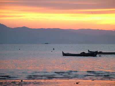
A heart touching view of Santa Catarina
A Sunset view of the island
Sunday 3 February 2013
BANJOSA LAKE AZAD KASHMIR (PAKISTAN)
Banjosa Lake is an artificial lake situated at a distance of
20 Km away from the city of Rawalkot in District Poonch in Azad Kashmir
Pakistan. This lake is located at a
height of 1980 meters (6499 ft) above sea.
It is a tourist attractive site.
There is thick forest of pine trees around the lake which
makes it very charming and romantic place.
Mountains are also surrounding the lake adding the more beauty to this
site. In this area, the weather remains
cool and pleasant even in summer. Winter
is always cold and chilly here. Visitors
may enjoy snowfall in December and January.
The lake is accessible by a metallic road from Rawalkot. During your travel the this lake you may take
rest at many huts and rest houses provided by Tourism &
Archaeology Department, Pearl development and Pakistan public works Department.
Subscribe to:
Posts (Atom)


